![‘Bahrein. Maps showing areas of land belonging to and leased by R.A.F. No. BAH 109’ [‎15r] (1/2)](https://iiif.qdl.qa/iiif/images/81055/vdc_100000000193.0x0003e5/IOR_R_15_2_262_0030.jp2/full/!1200,1200/0/default.jpg "‘Bahrein. Maps showing areas of land belonging to and leased by R.A.F. No. BAH 109’ [‎15r] (1/2)")
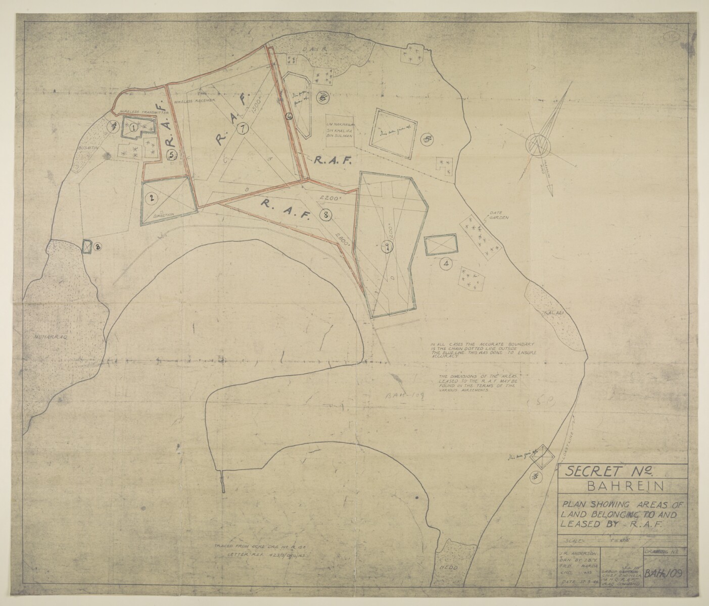
‘Bahrein. Maps showing areas of land belonging to and leased by R.A.F. No. BAH 109’ [15r] (1/2)
The record is made up of 1 map. It was created in 17 May 1946. It was written in English. The original is part of the British Library: India Office The department of the British Government to which the Government of India reported between 1858 and 1947. The successor to the Court of Directors. Records and Private Papers Documents collected in a private capacity. .
About this item
- Content
Distinctive Features:
Copied from drawing no. R15A and enclosed to letter from the RAF Chief Engineer (folio 12) dated 18th August 1950.
Shows the land owned by the RAF and civilian air authorities with position of wireless transmitters indicated and dimensions reported. Plots outlined in colour and numbered for reference with a key provided in ‘Schedule of leased and purchased land’ at folio 13.
- Extent and format
- 1 map
- Area map covers
- Map loading...
- Scale
- Scale not given
- Scale designator
- Horizontal
- Orientation
- North
- Degree coordinates
- Top-left: 26° 17' 25.22" N, 50° 36' 21.87" E
Top-right: 26° 17' 25.22" N, 50° 39' 48.6" E
Bottom-left: 26° 14' 35.46" N, 50° 36' 21.87" E
Bottom-right: 26° 14' 35.46" N, 50° 39' 48.6" E - Physical characteristics
Materials: Photographic print with additions in black ink and crayon
Dimensions: 663 x 782 mm, on sheet 690 x 810 mm
- Written in
- English in Latin script View the complete information for this record
Use and share this item
- Share this item
‘Bahrein. Maps showing areas of land belonging to and leased by R.A.F. No. BAH 109’ [15r] (1/2), British Library: India Office Records and Private Papers, IOR/R/15/2/262, f 15, in Qatar Digital Library <https://www.qdl.qa/archive/81055/vdc_100023512776.0x00001e> [accessed 30 May 2024]
https://www.qdl.qa/en/archive/81055/vdc_100023512776.0x00001e
Copy and paste the code below into your web page where you would like to embed the image.
<meta charset="utf-8"><a href="https://www.qdl.qa/en/archive/81055/vdc_100023512776.0x00001e">‘Bahrein. Maps showing areas of land belonging to and leased by R.A.F. No. BAH 109’ [‎15r] (1/2)</a> <a href="https://www.qdl.qa/en/archive/81055/vdc_100023512776.0x00001e"> <img src="https://iiif.qdl.qa/iiif/images/81055/vdc_100000000193.0x0003e5/IOR_R_15_2_262_0030.jp2/full/!280,240/0/default.jpg" alt="" /> </a>
This record has a IIIF manifest available as follows. If you have a compatible viewer you can drag the icon to load it.https://www.qdl.qa/en/iiif/81055/vdc_100000000193.0x0003e5/manifestOpen in Universal viewerOpen in Mirador viewerMore options for embedding images
Copyright: How to use this content
- Reference
- IOR/R/15/2/262, f 15
- Title
- ‘Bahrein. Maps showing areas of land belonging to and leased by R.A.F. No. BAH 109’
- Pages
- 15r, 15r
- Author
- East India Company, the Board of Control, the India Office, or other British Government Department
- Usage terms
- Open Government Licence